Loma Del Pliegue Tumbado Trail, Feb 4, 2016
Better weather for viewing Cerre Torre and Fitz Roy peaks in Glacier Nat Park. This 13 mile round trip trail provides great views and crossed over an area with marine fossils. Img 53872 Ritzroy Glacier Loma Del Pliegue Tumbado Trail
Iguazu Falls – Jan 28, 2016
Iguazu Falls is in northern Argentina on the border with Brazil about 1.5hr flight from Buenos Aries. The Iguazu River falls over the edge of the Paran Plateau creating numerous waterfalls over a span of 1.7 miles of which about 2/3 have water flowing over the edge. Iguazu Falls are claimed to be the 2nd widest falls in the world. There are walkways to allow easy access to the various falls both from above and below. It was hot and humid. Img 52639 Iguazufalls
Iguazu Falls Rainbow – Jan 28, 2016
Saw multiple rainbows because the sun was out (but also meant it was hot and humid) Iguazu Falls is in northern Argentina on the border with Brazil – about 1.5hr flight from Buenos Aries. The Iguazu River falls over the edge of the Paran Plateau creating 275 waterfalls. Img 52978 Iguazufalls
Iguazu Falls – Lower Circuit, Jan 29, 2016
Iguazu Falls are owned by the two UNESCO World Heritage Sites: the Iguaz National Park in Argentina and the Iguau National Park in Brazil. Img 53069 Lowercircuit Iguazufalls
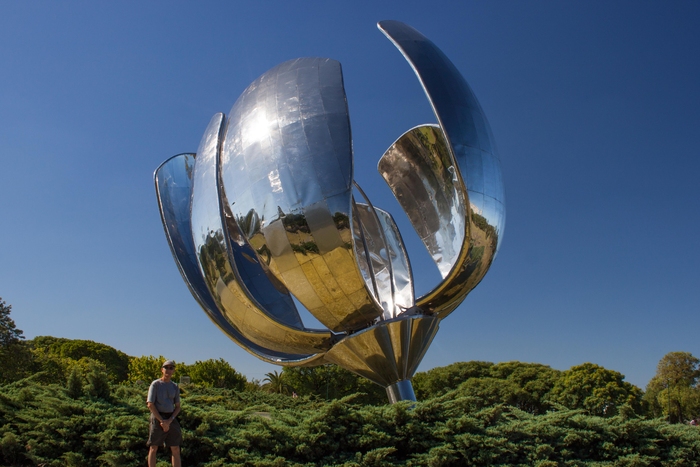
Floralis Genrica, Buenos Aries, Jan 31, 2016
Floralis Genrica is a sculpture made of steel and aluminum in Buenos Aries by the Argentine architect Eduardo Catalano. The sculpture was designed to move, closing its petals in the evening and opening them in the morning. Img 53435 Floralisgenerica Buenosaries
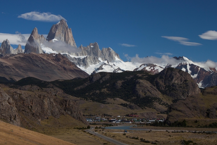
Patagonia Fitz Roy and Cerre Torre above Chalten, Feb 2, 2016
Entering Glacier National Park in the Patagonia region in Argentina we were greeted to this view of the peaks Fitz Roy (highest) and Cerre Torre (left of Fitz Roy) rising above the Argentine town of Chalten. This was our base for hiking the next two days. Img 53469 Chalten
Laguna de Los Tres Hike, Feb 3, 2016
Our first hike in Patagonia was the Laguna de los Tres up to the lake below the peaks of Ritz Roy and Cerre Torre. Fitz Roy stayed in the clouds the whole time we were there but Cerre Torre was visible. The water of the glacier fed lake was very cold and it was windy. Great views! Img 53664 Ceretorre Fitzroy Laguna de Los Tres Hike
Randy at Laguna de Los Tres, Feb 3, 2016
11 mile round trip hike Img 53685 Laguna de Los Tres Hike
Pablo, Feb 3, 2016
Our guide, Pablo, explains the second hike in Glacier Nat Park at the trailhead. Img 53791 Pablo Glacier Loma Del Pliegue Tumbado Trail
Randy and Tom with Cerre Torre and Fitz Roy behind – Feb 4, 2016
Img 53898 Loma Del Pliegue Tumbado Trail
View of the mountain range as we leave Chalten, Feb 5, 2015
Img 53922 Glacier Natpk ChaltenGlacier National Park
Moreno Glacier, Feb 5, 2016
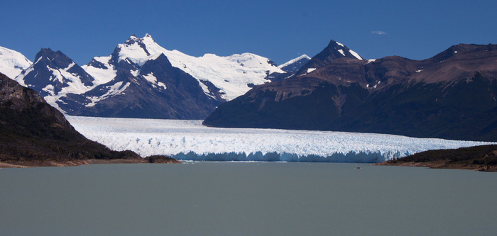
We took a boat ride out to the south face of the Moreno Glacier in Glacier National Park. If you look on the right side you can see a speck that is large boat in the distance. The glacier is over 200 feet high. Img 53943 Morenoglacier
Randy with Moreno Glacier, Feb 5, 2016
The Moreno glacier is one of the few glaciers in the world that is still advancing. The steep mountain peaks direct the moist pacific winds upward to generate the snow that feeds the glacier. Img 54032 Morenosglacier
Moreno Glacier Dam, Feb 5, 2016
The Moreno glacier creates a ice dam against the rock. The Lake on the south side was about 20 feet above the north lake (no outlet for the south lake). Every few years the dam breaks and the level of the lakes equalize, then the dam forms again and the cycle is repeated. Img 54073 Morenosglacier
Moreno Glacier Calving, Feb 5, 2016
We were lucky enough to witness a section of the north face of the Moreno glacier calving (breaking off). The 200+ foot high chunk made quite a wave and noise. Img 54139morenoglacer n Calving11
Estancia Nibepo Aike, Feb 6, 2016
Our next stay was on a working sheep ranch in Glacier Nat. Park. The ranch was named after the daughters of the owner. The ranch is in the foreground and Lago Roca beyond as we climb Crystal Ridge behind the ranch. We were introduced to the Gaucho experience: Sheep herding, lamb asado barbeque, etc. Img 54169 Estancia Nibepo Aike
Crystal Ridge, Feb 6, 2016
We hiked up the steep volcanic ridge behind Estancia Nibepo Aike. Found lots of large quartz crystals scattered about which gives the ridge its name. Great views from the top. Img 54184 Crystalridge
Crystal Ridge, Feb 6, 2016
View of our hiking group descending from Crystal Ridge. I am behind taking photos of wildflowers. Img 54233 Crystalridge
Sunrise, Estancia Nibepo Aike, Feb 6, 2016
Sunrise at the ranch. Img 54304 Estancia Nibepo Aike
Guanacos in Chile, Feb 7, 2016
Guanacos are related to Llamas and are plentiful in this area. I had a chance to taste guanacos on the last day of our REI tour similar to roast beef. We crossed over into Chile and were heading for Torres del Paine National Park. Img 54372 Guanacos
Paine Waterfall, Feb 7, 2016
Paine waterfall on the Paine river. Notice the person standing in the right edge of the photo to give perspective on how large this waterfall is. Img 54391 Painewaterfall
Torres Del Paine Viewpoint Hike, Feb 8, 2016
After a 6.2 mile (12.4 mile round trip) hike to the Torres Del Paine viewpoint we were rewarded with a great view of the mountain range with the glacier fed lake below. I met one guy that tried to swim in the lake but was not able to get in above his knees before the pain turned him back. Img 54482 Painetowers Viewpoint
Torres Del Paine, Feb 8, 2016
Img 54576 Torres Del Paine
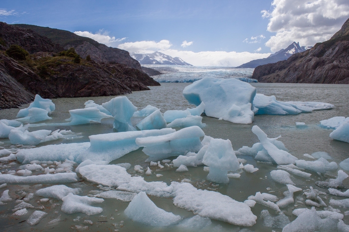
Grey Glacier, Feb 9, 2016
View of Grey Glacier after a 6.8 mile hike in (13.6 mile round trip) Img 54679 Greyglacier
French Valley Hike, Feb 10, 2016
Our longest hike of the trip (one guide said 17 miles, the other said 18 miles) Great views of the valley, glaciers and peaks. Our guides indicated this lake did not have a name – it was close to Lake Skottsberg. Img 54714 Skottsberglake Frenchvalley
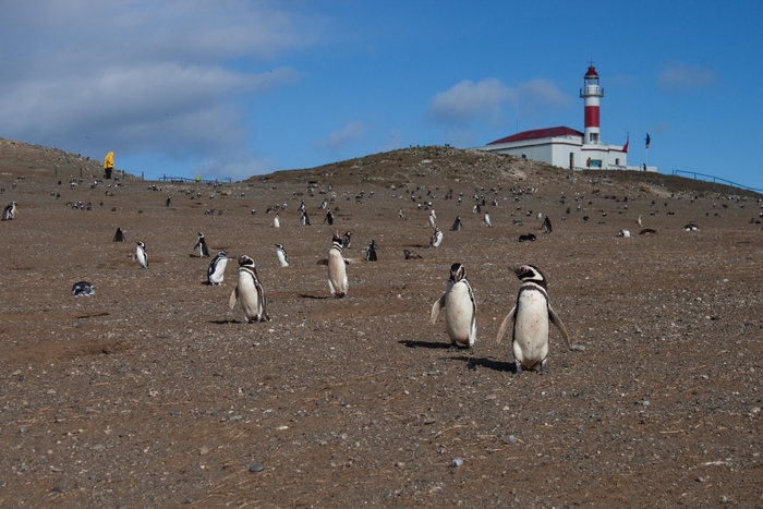
Magellan Penguins of Magdalena Island, Feb 13, 2016
We took a boat out to Magdalena Island in the Magellan Strait to see the 150,000 nesting Magellan penguins. The National park has designated walkways to keep people out of the nesting area but the penguins would cross right in front of you sometimes coming within a couple of feet. Img 54998 Magdalena
Magellan Penguin Chick, Feb 13, 2016
The fine down feathers of Magellan chicks are not waterproof, and the chicks must remain out of the water until they acquire their juvenile plumage. Img 55001 Magdalena
Marching Penguins, Feb 13, 2016. This group of penguins were heading for the water. Img 55019 Magdalena









I love your great pictures!
Absolutely breath-taking!!!